 Sale!
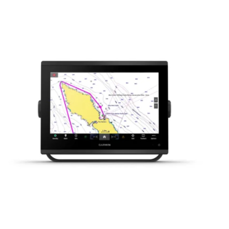
Sale! Garmin GPSMAP 1223 Non-sonar with Worldwide Basemap
$100.00
$2,799.99
Quick Overview
In the BoxGPSMAP 1223 chartplottermicroSD card preinstalledPower cableNMEA 2000 T-connectorNMEA 2000 drop cable (2 meters)Bail mount kit with knobsFlush mount kit with gasketProtective coverTrim piece snap coversDocumentationGeneralDIMENSION12.1 x 8.9 x 3.
- Satisfaction 100% Guaranteed
- Free shipping on orders over $30
- 60 day easy Return
In the Box
- GPSMAP 1223 chartplotter
- microSD card preinstalled
- Power cable
- NMEA 2000 T-connector
- NMEA 2000 drop cable (2 meters)
- Bail mount kit with knobs
- Flush mount kit with gasket
- Protective cover
- Trim piece snap covers
- Documentation
| General | |
|---|---|
| DIMENSION | 12.1 x 8.9 x 3.2 (30.8 x 22.8 x 8.2 cm) |
| WEIGHT |
6.6lbs(3.0 kg) |
| WATER RATING |
IPX7 |
| TOUCHSCREEN | Yes |
| DISPLAY TYPE | WXGA |
| DISPLAY SIZE | 10.3″ x 6.4″; 12.1″ diagonal (26.2 x 16.3 cm; 30.7 cm diagonal) |
| DISPLAY RESOLUTION | 1280 x 800 pixels |
| MOUNTING OPTIONS | Bail, flush or flat (Garmin does not offer any hardware or accessories for a flat-mount installation. Professional tools and knowledge is required.) |
| INPUT | Touchscreen |
| Maps & Memory | |
|---|---|
| ACCEPTS DATA CARDS |
2 microSD cards |
| WAYPOINTS |
5000 |
| TRACK POINTS | 50,000 |
| TRACKS | 50 saved tracks |
| NAVIGATION ROUTES | 100 |
GET A SHARPER VIEW FROM YOUR CONNECTED HELM
With its sleek design, powerful processing and upgraded IPS display, this advanced 7, 9, 12 or 16 chartplotter integrates seamlessly into your Garmin marine system.
Easily integrate with more engines.
Connect to compatible third-party devices with digital switching and OneHelmintegrations.
Easily build your marine system by using our advanced network connectivity.
Navigate any waters with preloaded Garmin Navionics+charts on select models.
See below your boat with built-in sonar capabilities on select models.
Manage your marine experience from nearly anywhere1.
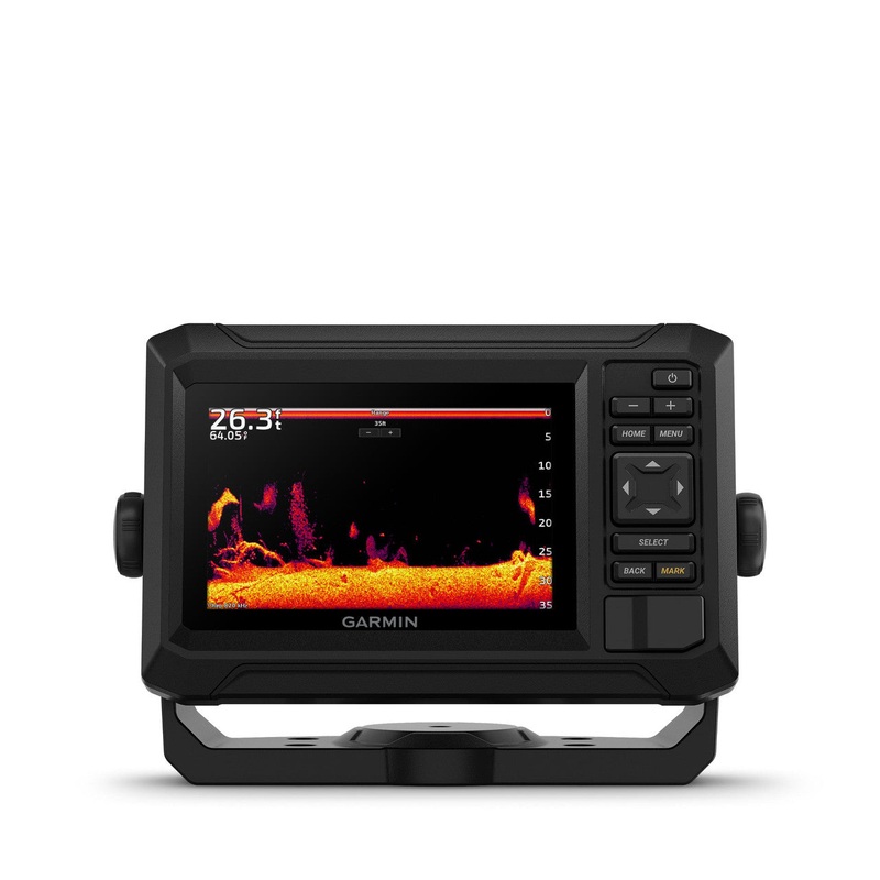
ULTRA HIGH-DEFINITION SCANNING SONAR
Get built-in Ultra High-Definition SideVand ClearVscanning sonarswith vivid, high-contrast color palettes to help distinguish fish from structure. The GPSMAP X3 chartplotter series also supports 1 kW traditional sonar capabilities.
LIVE SONAR SUPPORT
Pair with Panoptixor LiveScopeeasy-to-interpretlive sonar(transducer required, sold separately) to see all around your boat in real time.
FASTER, SHARPER, SMARTER
With its added processing power and slimline design featuring edge-to-edge glass, its easy to fit this plotter in a wider range of dash configurations.
BRIGHT AND CLEAR OPTICS
High-resolutionIPS displaysfor 9, 12 or 16 chartplotters offer improved sunlight readability and visibility from any angle.
PRELOADED MAPPING
Experience unparalleled coverage and detail with built-inGarmin Navionics+integrated coastal and inland mapping that includes Auto Guidance+technology2and a 1-year subscription for downloadabledaily updatesand more on select chartplotters.
OPTIONAL CHARTS AND MAPS
Bring a fresh new look and feel to your chartplotter with an optional upgrade to aGarmin Navionics Vision+premium chart subscription, featuring downloadable high-resolutionrelief shading, satellite imagery,sonar imageryand more.
OPTIONAL RADAR BUNDLE
To help you avoid weather and traffic on the water, the compact 4 kWGMR18 HD3dome radar is available as a bundled option with select GPSMAP chartplotter/sonar packages.
POWER-POLESHALLOW WATER ANCHOR
By networking your select Garmin chartplotters with a Forcetrolling motor and your compatible Power-Pole shallow water anchoring system, you can access advanced boat control features3from your plotter, including smart anchor auto-deployment, smart anchor jog, auto stow, anchor drag detection and end-of-route anchoring. Spend more time fishing, less time positioning.
TROLLING MOTOR INTEGRATION
Get support and integration for yourForce trolling motor(sold separately) to gain complete control while you fish.
CHARGE INTEGRATION FROM POWER-POLE
Your CHARGE Marine Power Manager from Power-Pole integrates with compatible Garmin chartplotters to help keep your battery power going longer and stronger on the water. Youre able to charge batteries on the run, monitor power use, select where power is allocated, control emergency starts and even transfer power between battery banks all from your chartplotter display.
| Cost: | $25 |
| Free Shipping | We offer free shipping on orders over $30. Please check the free - shipping eligibility at checkout. |
| Delivery Time: | It usually takes [3-5] business days for standard shipping. Please note that this is an estimated time frame and may be affected by local holidays, and unforeseen circumstances. |

Reviews
There are no reviews yet.